Save this image free of charge
in 800 pixels for layout use
(right click, Save as...)
|
|
Ref : T01534
Theme :
Looking at Earth - Mountains - Hills - Snow - Ice (539 images)
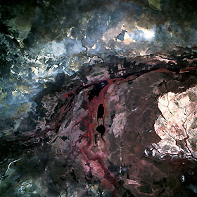
Title : Sudd Swamp and White Nile River, Southern Sudan May 1993
Caption :
The color infrared properties of the film vividly portray much of the subtle detail of the northernmost area of the Sudd Swamp, the extensive floodplain that reaches for 340 miles (540 kilometers) from the Uganda border to the city of Malakal in southern Sudan. The Sudd is composed of multiple channels, lakes, and swampland, with a maze of thick, emergent aquatic vegetation. The photograph shows the confluence of the Bahr el Jebel (White Nile River) and one of its main tributaries, the Bahr al Ghazal, which joins the White Nile 80 miles (130 kilometers) west of Malakal. The main channel of the White Nile, identified by the reddish swath (green vegetation) along both banks, runs generally north-south. The Bahr al Ghazal, with its multibraided channels, flows northeastward to merge with the main channel of the White Nile near Lake No. Darker (almost black) areas are pockets of open water or lakes. The sizable whitish area along the southeast margin of the photograph is believed to be grassland that has been overgrazed by cattle. This photograph was taken during the driest time of year—summer rains generally extend from July through September.
|
|

